
Page 63 - Demo
P. 63
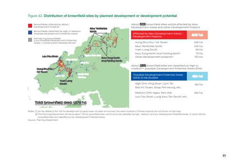
[1] As the details of the 150 ha development projects have not been announced, the exact locations of these projects are not shown on the map.[2]Hung Shui Kiu / Ha TsuenNew Territories NorthYuen Long SouthKwu Tung North and Fanling NorthOther development projects[1]High DPA—Ping Shan, Lam Tei, Sha Po Tsuen, Shap Pat Heung, etc.Medium DPA—Ngau Tam Mei, Lau Fau Shan, Lung Kwu Tan South, etc.160 ha246 ha243 ha94 ha70 ha150 haAffected by New Development Areas / Development Projects 803 haPossible Development Potential Areas (DPA) to be studied 450 haFigure 42. Distribution of brownfield sites by planned development or development potentialAbout 50% brownfield sites will be affected by New Development Areas and other Development ProjectsAbout 28% brownfield sites are classified as high or medium[2] possible Development Potential Areas (DPA)Yuen LongSouthKwu Tung Northand Fanling NorthHung Shui Kiu / Ha TsuenLau Fau ShanPing ShanSha PoNgau Tam MeiShap PatHeung Lam TeiNew TerritoriesNorthTotal brownfield area: 1,579 haBrownfields affected by NDAs /Development ProjectsBrownfields classified as High or MediumPossible Development Potential AreasRemaining brownfields(Low Possible Development PotentialAreas / Conservation Related Zones)The Planning Department will study about 700 ha brownfield sites, which are to be classified as high, medium, and low Development Potential Areas, of which 250 ha brownfield sites are classified as low Development Potential Areas.Source: Planning Department290 haNotes:61
