
Page 36 - Demo
P. 36
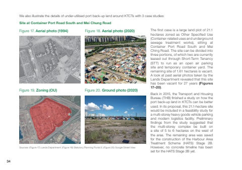
Sources: (Figure 17) Lands Department; (Figure 19) Statutory Planning Portal 2; (Figure 20) Google Street ViewFigure 17. Aerial photo (1994) Figure 18. Aerial photo (2020)Figure 19. Zoning (OU) Figure 20. Ground photo (2020)We also illustrate the details of under-utilised port back-up land around KTCTs with 3 case studies:The first case is a large land plot of 21.1 hectares zoned as Other Specified Use (Container-related uses and underground sewage treatment works), sitting at Container Port Road South and Mei Ching Road. The site can be divided into three portions, of which two are currently leased out through Short-Term Tenancy (STT) to run as an open air parking site and temporary container yard. The remaining site of 1.61 hectares is vacant. A look at past aerial photos taken by the Lands Department revealed that this site has been vacant for 27 years (Figures 17–20).Back in 2015, the Transport and Housing Bureau (THB) finished a study on how the port back-up land in KTCTs can be better used. In its proposal, this 21.1-hectare site would be included in a feasibility study for a multi-storey heavy goods vehicle parking and modern logistics facility. Preliminary findings from the study suggested that the multi-storey complex be built on a site of 5 to 6 hectares on the west of the area. The remaining area was saved for the construction of the Harbour Area Treatment Scheme (HATS) Stage 2B. However, no concrete timeline has been set for the HATS Stage 2B yet.Site at Container Port Road South and Mei Chung Road34
